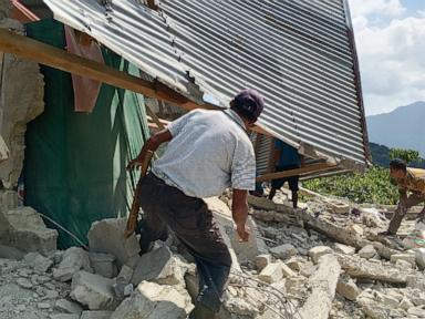
Geophysical disruptions in convergent tectonic boundaries obey precise mechanical laws rather than arbitrary geography. When a magnitude 7.7 seismic event ruptures off the coast of Flores Island, followed sequentially by secondary tectonic adjustments such as the 6.4-magnitude tremor recorded on Sumatra, the impact is governed by energy attenuation curves, fault-line geometry, and local infrastructure load-bearing capacities. Analyzing these concurrent events requires moving past surface-level casualty reporting to evaluate the mechanical propagation of seismic energy and the systemic bottlenecks that amplify disaster severity.
The Energy Release and Attenuation Mechanics
The primary mechanism dictating structural destruction is the log-normal scaling of seismic moment magnitude. A 7.7-magnitude earthquake releases approximately $1.99 \times 10^{15}$ joules of energy, roughly 32 times greater than a 6.7-magnitude event. The hypocenter depth of approximately 10 to 15 kilometers placed the energy source well within the brittle crust of the Flores region.
Shallow focal depths restrict the spatial distribution of the energy cone, concentrating destructive peak ground acceleration (PGA) in a tight radius before geometric and inelastic attenuation reduce wave amplitudes. Consequently, regencies situated directly along the Flores arc experienced maximum intensity shaking.
The subsequent occurrence of a 6.4-magnitude tremor on Sumatra represents an independent strain release along a separate segment of the Sunda megathrust system. While casual observers often conflate simultaneous seismic spikes as direct trigger chains across thousands of kilometers, seismological analysis confirms these events highlight the broader stress field loading across the Indo-Australian and Eurasian plate boundaries rather than direct hydraulic or elastic shock transfer across distant fault systems.
Infrastructure Vulnerability and the Failure Vector Matrix
Structural survivability during high-magnitude shallow earthquakes depends on lateral load resistance. The structural failures observed across Sikka, Manggarai, and Nagekeo regencies stem from specific physical failure vectors:
- Ductility Deficits: Unreinforced masonry and non-engineered concrete structures lack the steel reinforcement necessary to absorb cyclical shear stresses induced by surface waves.
- Foundation Liquefaction Susceptibility: Coastal alluvial deposits in regions like Maumere amplify low-frequency waves, turning loose, water-saturated soils into semi-fluid masses that compromise building foundations.
- Topographic Amplification: Ridge lines and steep mountain slopes focus seismic wave energy near summits, explaining why inland areas experienced severe localized landslides despite being distant from the submarine epicenter.
Lifeline infrastructure components suffered cascading failures. The obstruction of the Trans-Flores highway by debris flows in Ende regency severed the primary overland logistical artery. When arterial transport corridors fail simultaneously with electrical grid collapses—which disable local communications—the command-and-control feedback loop necessary for search and rescue operations breaks down. Emergency response efficiency is inversely proportional to the time required to clear primary logistical bottlenecks.
Tsunami Warning Latency and Coastal Risk Mitigation
The generation of an undersea tsunami threat is governed by the vertical seabed displacement vector associated with strike-slip versus dip-slip faulting. Following the initial shock, the Meteorology, Climatology, and Geophysics Agency (BMKG) instituted regional tsunami alerts based on real-time sea-level sensor telemetry.
The recorded wave heights remaining under one meter across monitored coastal zones indicate that the fault rupture possessed a significant horizontal component or occurred at a depth profile that limited massive vertical water column displacement. However, the institutional decision-making framework mandates conservative evacuation protocols.
Over 2,000 residents self-evacuated to higher ground in Nagekeo before the warning was formally lifted. This behavioral response highlights a functioning risk-awareness threshold among coastal populations historically conditioned by major historical precedents, such as the destructive 1992 Flores earthquake and tsunami. The economic cost of false-positive evacuations is negligible compared to the alternative tail risk of unmitigated wave inundation.
Resource Allocation under Geographic Constraints
Logistical deployment in island archipelagos introduces severe spatial constraints. East Nusa Tenggara's fragmented geography prevents rapid heavy-machinery deployment via ground transit. The National Disaster Management Agency (BNPB) deployment of rotary-wing aircraft and marine vessels addresses the core constraint of maritime isolation.
Medical infrastructure resilience requires immediate off-grid operational shifts. Hospitals in Ende and Maumere successfully transferred patients and critical care assets (such as oxygen cylinders and monitoring equipment) to outdoor triage spaces. This decentralization strategy isolates medical operations from post-mainshock structural collapse hazards while maintaining treatment continuity.
Prioritize hardening secondary arterial roads through geotechnical slope stabilization along high-risk mountain corridors while establishing decentralized, pre-positioned modular emergency caches on individual islands to bypass inter-island transit delays during primary communications blackouts.



 sin fondo.png)