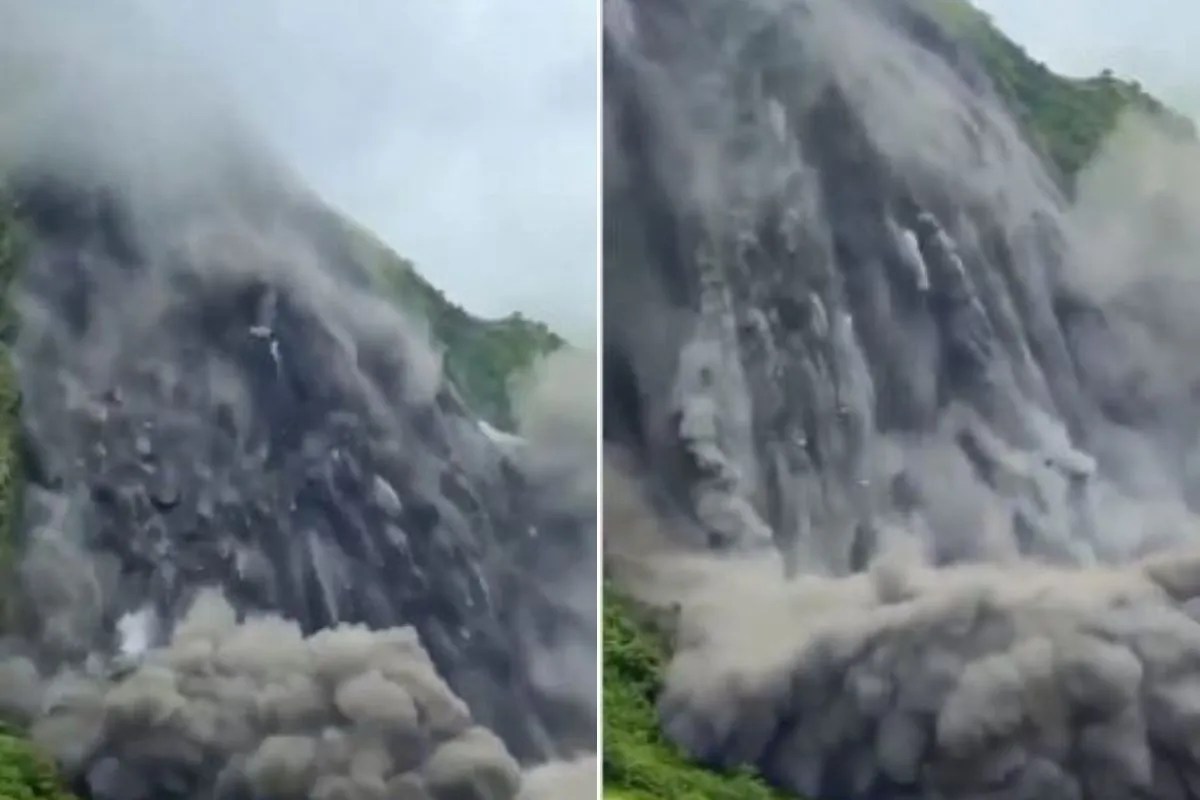
Unstable slope failures in high-relief mountain systems create immediate hydrodynamic hazards that extend far beyond the localized footprint of the initial mass movement. When thousands of tons of rock and soil detach from saturated terrain and enter a confined river valley, the resulting channel constriction alters hydraulic gradients, sediment transport capacity, and downstream discharge volumes. The recent mass movement at the Bhattar sector within the Api Himal Rural Municipality of Nepal's Darchula district, which partially obstructed the Chaulani River (also known as the Chameliya River), exemplifies the systemic vulnerability of Himalayan drainage networks to secondary flash-flood triggers.
Mechanics of Valley Constriction
The primary mechanical hazard of a partial or complete river blockage is the creation of an ephemeral natural dam. When debris from a hillslope failure accumulates across a riverbed, inflow from upstream continues to supply water, whereas outflow is restricted by the porous or dense matrix of the landslide mass. This hydraulic imbalance produces several distinct physical effects:
- Headwater Pooling: Water accumulates upstream of the debris mass, forming a temporary impoundment basin. The rate of water level rise is a direct function of upstream discharge volume versus the residual seepage and overflow capacity of the obstruction.
- Pore-Pressure Elevation: As water levels rise behind the barrier, hydrostatic pressure increases against the upstream face of the landslide dam. This infiltration saturates the internal matrix, reducing shear strength and increasing the likelihood of sudden structural collapse.
- Downstream Flow Deprivation Followed by Surging: While the blockage restricts flow, downstream reaches experience a temporary reduction in discharge. This apparent stabilization is deceptive; it masks the escalating potential energy stored behind the unstable debris barrier upstream.
In the case of the Chaulani River corridor, security personnel from the Nepal Chameliya Hydropower Security Base in Balanch were deployed to monitor water levels because any sudden breach of the accumulation zone threatens critical energy infrastructure and surrounding settlements along the riverbanks down to its confluence with the Mahakali River.
The Dynamics of Natural Dam Failure
Natural landslide dams rarely fail through controlled, gradual overtopping. The heterogenous mixture of boulders, fine sediment, and organic debris lacks engineered spillways, armor plating, or internal drainage filters.
When overtopping occurs, the concentrated flow erodes the crest of the dam. As water cuts downward through loose material, the discharge rate accelerates exponentially. This positive feedback loop—higher velocity increasing erosion, and increased erosion accelerating velocity—results in catastrophic dam break waves.
The downstream risk profile is dictated by three primary variables:
- Volume of the Impoundment: The total cubic capacity of the temporary reservoir determines the total potential energy available to be converted into kinetic energy during a breach.
- Geotechnical Composition of the Barrier: Cohesive clay-rich slide masses may form more stable, longer-lasting barriers than cohesionless sandy-gravel debris flows, which erode rapidly upon contact with running water.
- Channel Morphology Downstream: Narrow, steep gorges concentrate the flood wave, maintaining high velocities and destructive potential over longer distances, whereas wide, flat floodplains allow the energy to dissipate through lateral expansion.
Regional Vulnerability and Cumulative Stress
The obstruction in Darchula does not occur in isolation. Mountain catchments subjected to repeated high-intensity monsoon events experience cumulative degradation. Soil mantles become completely saturated, lowering the threshold of rainfall required to trigger subsequent mass movements.
Data compiled by disaster management authorities indicate that widespread flooding and slope failures across Nepal have placed severe strain on civil infrastructure, including transport links, suspension bridges, and hydropower facilities. When multiple sub-basins experience simultaneous instability, emergency response resources are fragmented, complicating evacuation protocols and real-time monitoring efforts.
In regions where rivers form international boundaries—such as the Mahakali River system shared by Nepal and India—cross-border hydrological continuity requires synchronized early-warning communication. A surge originating in the steep upper catchments of Darchula can traverse international river segments within hours, making rapid data transmission between hydrological stations and local administrative units essential for life safety.
Operational Mitigation and Monitoring Protocols
Managing the risk profile of landslide-blocked river systems relies on continuous observation rather than passive forecasting. Because exact time-to-failure calculations for debris dams remain mathematically indeterminate due to the unpredictable internal hydrology of slide masses, operational strategies must focus on instrumentation and trigger-based evacuation thresholds:
- Upstream Stage Monitoring: Installation of remote telemetry sensors above the constriction zone to detect anomalous drops in downstream flow or rapid upstream pooling, which signal active channel choking.
- Downstream Time-of-Travel Modeling: Pre-calculated hydrodynamic models that map out exact arrival times for potential flood waves across critical population centers and infrastructure nodes at varying discharge rates.
- Phased Relocation Triggers: Establishing strict operational boundaries where physical movement out of the active floodplain is mandatory based on cumulative precipitation measurements and slope movement velocity indicators, rather than waiting for visual confirmation of a breach.
Mitigating high-relief hydrological hazards requires shifting the operational posture from post-disaster recovery to continuous hydraulic surveillance of unstable tributary junctions. As slope stability decreases under the weight of recurring severe weather events, identifying marginal constrictions before they evolve into high-energy dam-break waves remains the primary defense for downstream communities.