The air changes first. It is not something you see on a radar screen or read in a weather notification pinging on your phone. It is a sudden, heavy stillness that settles over the standard Tuesday afternoon bustle along 17th Avenue. The morning’s crisp Alberta breeze simply vanishes. In its place sits a thick, metallic heat that clings to the skin and makes the hairs on your arms stand up.
To anyone who has spent a summer in southern Alberta, this specific silence is terrifying.
By 3:00 PM, Environment and Climate Change Canada formalizes what the old-timers’ aching joints already know. A severe thunderstorm watch is issued. It spans a massive, volatile corridor of the province, stretching from the glass towers of Calgary down through the wind-swept coulees of Lethbridge and out to the sun-baked plains of Medicine Hat. The official alerts warn of nickel-sized hail, localized flooding, and winds capable of tearing shingles from roofs at 90 kilometers per hour.
But a government alert is just data. It is a collection of coordinates and meteorological thresholds. The real story of a storm is told in the frantic scramble of a city trying to protect what it loves before the sky turns green.
The Anatomy of the Atmosphere
To understand why this specific stretch of Western Canada is so prone to atmospheric violence, you have to look at the geography. Consider a hypothetical resident named Sarah. She is sitting on a patio in downtown Calgary, watching a bank of bruised, purple clouds build over the jagged peaks of the Rocky Mountains to the west.
The mountains are beautiful, but they are also a trigger.
As warm, moist air pushes north from the Gulf of Mexico, it collides with the cool, dry air rolling down the eastern slopes of the Rockies. The mountains force this warm air upward into the colder layers of the upper atmosphere. This process is called orographic lift. Think of it like a giant, invisible ramp. The moisture rides up this ramp, cooling rapidly as it ascends.
When that warm, moist air meets the freezing upper atmosphere, it creates severe instability. The air begins to churn violently. It is a massive, thermodynamic engine fueled by heat and moisture.
[Atmospheric Instability: Warm Gulf air meets cool mountain air, forcing rapid updrafts]
As the water droplets are forced upward by powerful updrafts, they freeze into ice. If the updraft is strong enough, it keeps those ice pellets suspended in the sky, tossing them up and down like popcorn in a machine. Each time the ice pellet takes a trip up and down through the cloud, it coats itself in a new layer of water, which promptly freezes. This is how a raindrop transforms into a jagged chunk of hail.
The Waiting Game in Lethbridge and Medicine Hat
Two hours south, down the asphalt ribbon of Highway 2, the tension is different. In Lethbridge, the wind is already beginning to howl through the river valley. Lethbridge is a city defined by its wind, but today, the gusts feel erratic. They whip up dust storms from the surrounding farmland, blinding drivers on the Whoop-Up Drive bridge.
The watch here means something different than it does in the city. In the agricultural hubs surrounding Lethbridge and Medicine Hat, a severe thunderstorm is not just an inconvenience for commuters. It is a direct threat to a family's livelihood.
Imagine a multi-generational farming family just outside of Taber, halfway between Lethbridge and Medicine Hat. The crops are high, green, and vulnerable. A single fifteen-minute barrage of direct, heavy hail can erase an entire year’s income. It can shred canola plants to toothpicks and dent combines beyond recognition.
When the watch is issued, the farmers do not check the radar once; they keep it open on their dashboards. They look at the sky with a specific kind of resignation. You cannot build a roof over a thousand acres of wheat. You can only watch the western horizon and pray that the cell splits before it reaches your fence line.
In Medicine Hat, the sun is still beating down fiercely, pushing temperatures toward the mid-thirties. This extreme heat acts as high-octane fuel for the impending storm system. The higher the temperature at the ground, the more violently the air will rise when the cold front finally cuts through. The city sits in a valley, a natural bowl that traps heat, creating a perfect localized breeding ground for severe weather.
The Shift from Watch to Warning
There is a common confusion that happens every time the weather office issues an alert. People often conflate a watch with a warning. The distinction is critical, and understanding it can mean the difference between a minor inconvenience and a tragedy.
A severe thunderstorm watch means that the atmospheric ingredients are all present in the kitchen. The moisture is there. The heat is there. The wind shear is there. The storm could happen, and it has the potential to be dangerous. It is a call for heightened awareness. It is the time to clean out your gutters, park your car in the garage, and make sure your patio furniture isn't going to become a missile.
A severe thunderstorm warning, however, means the cake is baking. A storm has been spotted on radar or by a trained weather spotter. It is happening now. It is tracking toward a specific neighborhood. The threat is imminent.
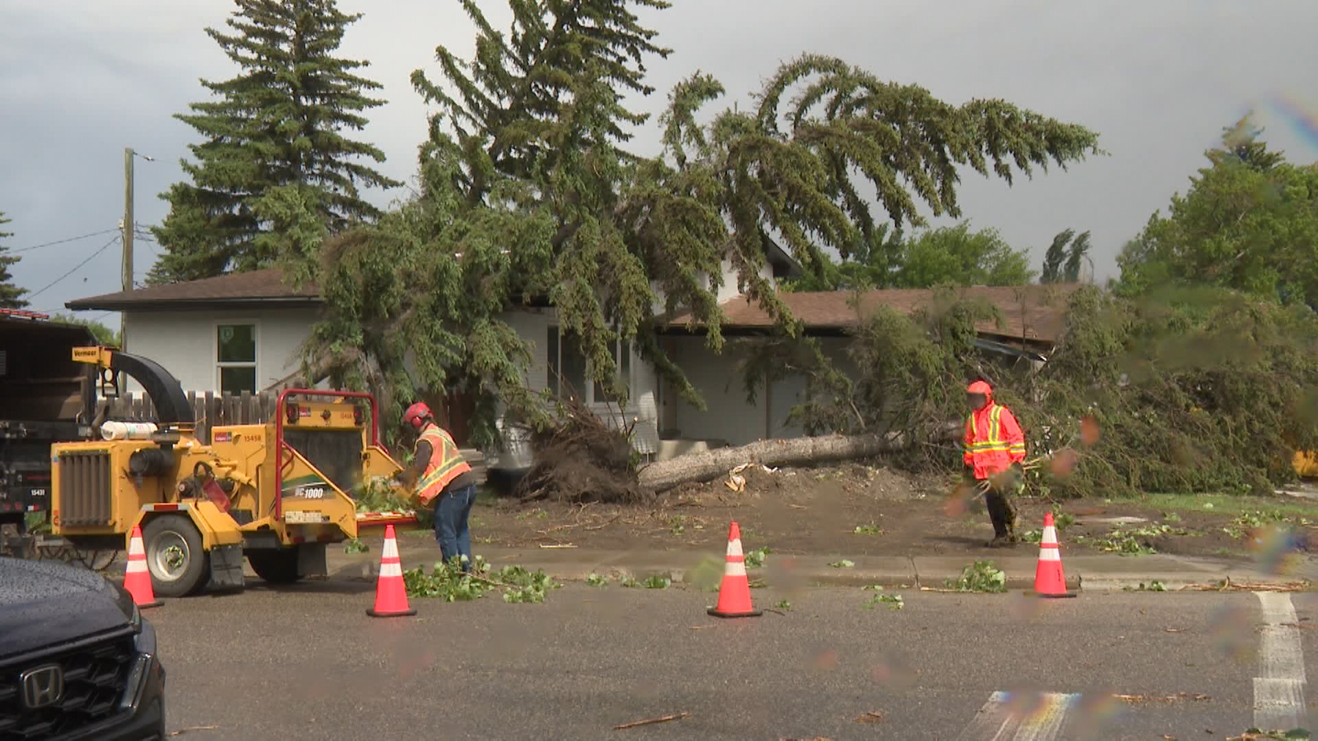
For Calgarians, the memories of June 2020 still linger like a scar. That was the year a severe hailstorm tore through the city’s northeast quadrant, causing over $1.2 billion in insured damages. It remains one of the costliest natural disasters in Canadian history. Siding was ripped from houses, windows were obliterated, and neighborhoods looked like they had been subjected to an artillery barrage.
That disaster changed how locals view a simple weather alert. It stripped away the collective complacency that often grows during beautiful summer months.
The Human Scramble
Back in Calgary, the atmosphere shifts from anticipation to action. At a car dealership along Macleod Trail, staff members abandon their desks. They jog out to the lot in their dress shirts, keys jingling, hurrying to move hundreds of thousands of dollars worth of pristine inventory under the metal canopies of the service bays.
In suburban backyards across the northwest, neighbors who rarely speak across their fences are suddenly working together. An elderly man struggles to drag a heavy tarp over his tomato plants; a teenager from next door jumps the fence to help him tie it down. Trampolines are flipped over and anchored. Potted petunias are crammed into garages.
The roads become a chaotic gridlock of collective anxiety. The Deerfoot Trail transforms into a slow-moving river of brake lights. Drivers look anxiously at the underpasses, calculating whether they can park beneath the concrete structures if the hail starts to fall, a dangerous practice that often causes massive traffic jams and accidents during major storms.
Then, the light changes.
The sun is completely swallowed by the advancing wall of cloud. The sky takes on a bruised, eerie green-yellow hue. This greenish tint is a phenomenon caused by the sheer volume of water and ice suspended in the massive storm clouds. The thick cloud blocks the red light from the sun, allowing only the shorter blue and green wavelengths to scatter through the intense moisture.
When you see that green light, you know the ice is coming.
The First Drop
The temperature drops ten degrees in a matter of minutes. The wind picks up, carrying the scent of ozone and wet dirt.
A single, fat raindrop hits the windshield of a car stopped at a light on Memorial Drive. It makes a loud, distinct thud. Then another. Within thirty seconds, the sky opens up. The rain does not fall straight down; it moves horizontally, driven by the 90-kilometer-per-hour gusts pushing ahead of the cold front.
The city holds its breath, waiting to see if the raindrops will harden into stone.
Up on the hills of Nose Hill Park, the view of the downtown core vanishes completely behind a grey sheet of precipitation. The lightning begins—not the distant, playful flashes of a summer evening, but sharp, violet bolts that strike the earth with simultaneous, deafening cracks of thunder that shake the floorboards of houses kilometers away.
In this moment, the data on the Environment Canada website becomes entirely real. The statistics about wind speed and precipitation levels translate into a community of over a million people hunkering down in basements, listening to the roar of nature outside their windows, wondering what their neighborhoods will look like when the sun comes back out.
The storm will pass, as they always do. It will roll east toward Saskatchewan, leaving behind a trail of shredded leaves, flooded intersections, and a community reminded, once again, of its own fragility. The sky will clear, the wind will die down, and the metallic heat will dissipate, replaced by the clean, cool scent of an Alberta evening.
But for now, the rain continues to hammer against the glass, a relentless reminder that we live at the mercy of the mountains and the sky.